Trail Walking Loir en Vallée - Ruillé sur Loir - Photo
 tracegps
tracegps

User

© OpenStreetMap contributors
Length
Length
21 km
Max alt
Max alt
150 m
Uphill gradient
Uphill gradient
253 m
Km-Effort
Km-Effort  
24 km
Min alt
Min alt
61 m
Downhill gradient
Downhill gradient
252 m
Boucle
Boucle
Yes
Creation date :
2014-12-10 00:00:00.0
Updated on :
2014-12-10 00:00:00.0

(0 Reviews)

Walking
Walking
3h30
Difficulty : Difficult

Scan this QR Code to open this trail in the SityTrail application

FREE GPS app for hiking

Logo SityTrail SityTrail

IGN / Geographical institutes

Download SityTrail from the App Store Download SityTrail from Google Play

Logo SityTrail SityTrail World

The world is yours!

Download SityTrail from the App Store Download SityTrail from Google Play Download SityTrail on Huawei AppGallery

About

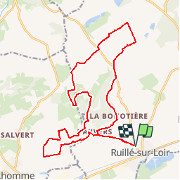
Trail Walking of 21 km to be discovered at Pays de la Loire, Sarthe, Loir en Vallée. This trail is proposed by tracegps.

Description

Ah!! la Sarthe ! Grandes forêts domaniales, rivières et plan d'eau, coteaux tapissés de vignes, routes tranquilles s'enfonçant dans la campagne...autant d'espaces à investir pour s'aérer l'esprit et retrouver la forme !

Elevation profile

Photos

Positioning

Country:
France
Region :
Pays de la Loire
Department/Province :
Sarthe
Municipality :
Loir en Vallée
Location:
Unknown
Start:(UTM)
321535 ; 5291650 (31T) N.

Trails nearby

Trail Hybrid bike La Chartre-sur-le-Loir - Le Loir, la Dême et le Long (CIRCUIT) - Photo
Hybrid bike
danaubrac

Hybrid bike

Medium
La Chartre-sur-le-Loir, Pays de la Loire, Sarthe, France
59 km | 67 km-effort
3h 20min
Yes
Trail Cycle La Chartre-sur-le-Loir - Vignes en Loir - Photo
Cycle
danaubrac

Cycle

Medium
La Chartre-sur-le-Loir, Pays de la Loire, Sarthe, France
55 km | 64 km-effort
Unknown
Yes
Trail Nordic walking Lhomme - Lhomme parcours de vigne  - Photo
Nordic walking
mamyzine

Nordic walking

Easy
Lhomme, Pays de la Loire, Sarthe, France
4.6 km | 5.4 km-effort
2h 16min
Yes


Close
My subscriptions